

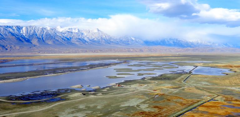
Owens Lake, located approximately 220 miles north of Los Angeles, is home to the Owens Lake Dust Mitigation Program (OLDMP), the largest air quality improvement project in the United States. Starting in 2000, the OLDMP has now installed 48.6 square miles of US EPA approved best available control measures (BACM) on the lake bed, resulting in a 99.4% reduction in dust emissions and a price tag of $2.5 billion to LADWP ratepayers. Operating and maintaining 48.6 square miles of BACM requires approximately 60,000 acre-feet of water annually, which is enough water for 240,000 single family households each year. The price tag includes initial capital costs, operation & maintenance, ever increasing regulatory fees, and replacement water costs from higher cost regional and State water sources.
While a primary objective is compliance with regulatory dust mitigation standards set forth by Great Basin Unified Air Pollution Control District (GBUAPCD), LADWP is committed to collaborating with multiple partners to balance a variety of other important goals, which include: water conservation, managing environmental resources such as wildlife habitat and cultural sites, maintaining public trust value, reliable dust mitigation infrastructure, operational resilience, improving safety, technological innovation, public outreach and education, and climate change sustainability.
Owens Lake: Balancing Dust Mitigation, Water Conservation, and Wildlife
History
Owens Lake is the natural terminus point for the Owens Valley water sheds, it is a remnant of a large prehistoric freshwater lake that extended some 60 miles up and down the Owens Valley and was over 300 feet deep. Gradually, as the climate of the area changed from post‐glacial to semi‐arid, the lake began to dry up. By the time settlers entered the valley in the mid‐19th century the lake had become a shallow saline desert sink, only a fraction of the size it had been in prehistoric times. Construction of the Los Angeles exacerbated the drying out of the Lake.
| 1800s | Canals built in the late 1800s diverted surface water for crop irrigation in the Owens Valley substantially reducing surface water inflow to Owens Lake. |
|---|---|
| 1906 |
The lake's water was thought to be excessively saline. Irrigation diversions by farmers, coupled with drought, dried the lake to about 5% of its historic volume by 1906. To support a growing population in Los Angeles, LADWP led by William Mullholland, completed the construction of the first LA Aqueduct in 1913, with diversions exposing additional playa. As a result, the exposed lakebed became emissive with dust that needed to be brought under control. |
| 1920s | Lakebed has been essentially dry since the late 1920s. Dissolved minerals and salts in the water crystallized into an alkali salt crust as the lake dried up. This crust used to cover much of the lakebed. |
| 1974 | Great Basin Unified Air Pollution Control District (GBUAPCD) established. The regulatory agency responsible for enforcing air quality standards in the Owens Valley. |
| 1980s | Beginning in 1980, the GBUAPCD and other researchers studied the lake environment and the mechanisms that caused Owens Lake’s severe dust storms. High winds on Owens Lake have the potential to cause erosion of the salt crust and develop wind‐blown dust. Dust is measured as PM10, or particulate matter less than 10 microns in diameter. |
| 1994 | Owens Valley Planning Area Best Available Control Measures State Implementation Plan established. |
| 1998 | In 1998 the City of LA signed a historic Memorandum of Agreement (MOA) with the GBUAPCD and accepted responsibility to reduce dust emissions from Owens Lake to meet the NAAQS for PM10 and began the Owens Lake Dust Mitigation Program to install and operate dust control measures on the lake bed. |
| 1999 | The MOA was incorporated into a formal air quality State Implementation Plan (SIP) developed and adopted by the District, and approved by the EPA in October 1999. |
| 2000s | Starting in 2000, LADWP has successfully implemented constructed and maintained 10 dust mitigation projects corresponding to various state implementation plans (SIPs), regulatory orders, settlement agreements, and stipulated judgements. To date the Owens Lake Dust Mitigation Program has successfully installed 48.6 square miles of federally-approved Best Available Control Measures resulting in a reduction of dust emissions by 99.4%. |
| 2003-2008 | The GBUAPCD prepared subsequent SIP revisions in 2003, 2008,(and again in 2016). |
| 2014 | Following years of litigation, LADWP and GBUAPCD policy makers reached a historic settlement agreement, known as the “Grand Bargain”. The settlement agreement was memorialized by the Sacramento Superior Court in the 2014 stipulated judgment and later codified by GBUAPCD in the 2016 State Implementation Plan. Key provisions of the stipulated judgment include clear limits on LADWP’s dust mitigation responsibilities to no more than 53.4 square miles, which includes 4.8 square miles of possible contingency orders. The upper limit is defined by the regulatory shoreline at 3,600 ft above mean sea level, while the lower limit is 3553.5 ft AMSL. |
| 2016 | The “Grand Bargain” and 2014 stipulated judgment led to GBUAPCD’s development of the USEPA approved 2016 State Implementation Plan for Attainment of National Ambient Air Quality Standards for PM 10 in the Owens Valley Planning Area (2016 SIP). The 2016 SIP establishes performance criteria for various US EPA approved dust mitigation methods with and provides a road map for achieving attainment of the 24-hour national ambient air quality standard (NAAQS) for particulate matter of 10 microns in aerodynamic diameter. Per GBUAPCD’s own modeling predictions, the milestone for attainment of NAAQS was December 31, 2020. Despite LADWP meeting all the requirements of the 2016 SIP, the Owens Valley Planning Areas (OVPA) has not been redesignated an area of “Attainment” for NAAQS. |
| 2024 | Dust emissions at Owens Lake have been reduced by 99.4%. To date, implementing, operating, and maintaining 48.6 square miles of dust mitigation has come at a cost of more than $2.5 billion to LADWP ratepayers. This dollar amount also includes ever increasing regulatory fees and replacement water purchases from strained regional and State sources. Great Basin’s annual regulatory fees have increased by nearly 50% since 2016. |
Dust Mitigation
High winds on Owens Lake have the potential to cause erosion of the salt crust and develop wind-blown dust. Dust is measured as PM10, or particulate matter less than 10 microns in diameter. These particles are extremely small, approximately one-tenth the diameter of a human hair, and when inhaled may cause a variety of health problems. Federal regulations have set health-based PM10 standards to prevent concentrations of suspended particles in the air that are injurious to human health. Prior to implementation of dust control measures by LADWP, dust originating from the lakebed was the major contributor to violations of the dust standard in the southern Owens Valley, and was the dustiest place in the United States.
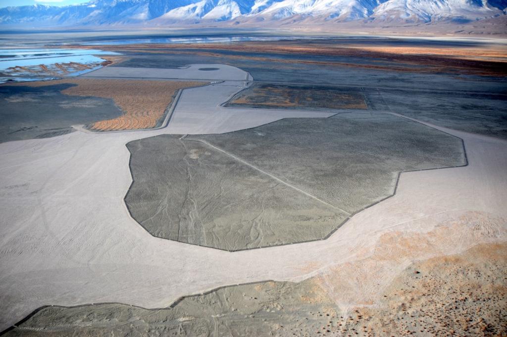
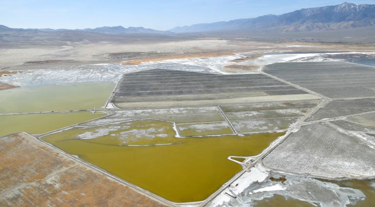
Today, LADWP operates and maintains 48.6 square miles of federally-approved Best Available Control Measure (BACM) to achieve a 99.4% reduction of dust emissions while creating incredibly productive habitat for birds and other wildlife. Owens Lake PM10 emissions were estimated at 62,377 tons/year in the year 2000 and 355 tons/year in 2023. BACMs include shallow flooding, managed vegetation, gravel, tillage with shallow-flooding backup, and brine with shallow-flooding backup, to contain and prevent dust emissions.
Best Available Control Methods
Shallow Flooding
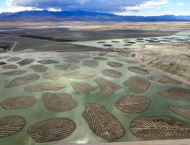
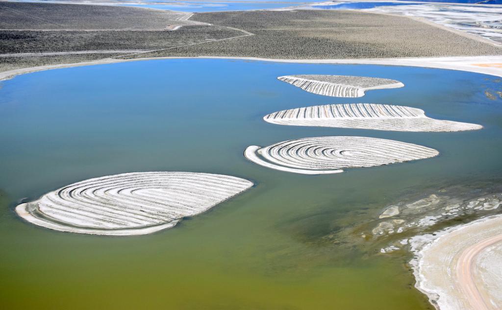
Shallow Flooding accounts for about 60 percent of the overall control measures. LADWP has installed one of the world’s largest shallow flooding systems consisting of a vast network of computer-controlled valves, pipes, outfalls, and sprinklers across the ancient lakebed. Shallow flooding prevents dust emissions by applying water to emissive playa surfaces, suppressing windborne dust. Currently, it is the predominant dust control method on Owens Lake, accounting for approximately 30 square miles of the program area. In order to meet the requirements for dust control within shallow flooding dust control areas, 72% - 75% of the graded surface must be maintained as wet or have saturated soil during the dust season, between mid-October and early July. The saturated surface eliminates dust generation and also traps blowing sand that enters the ponded area.
Brine with Shallow Flooding Back Up
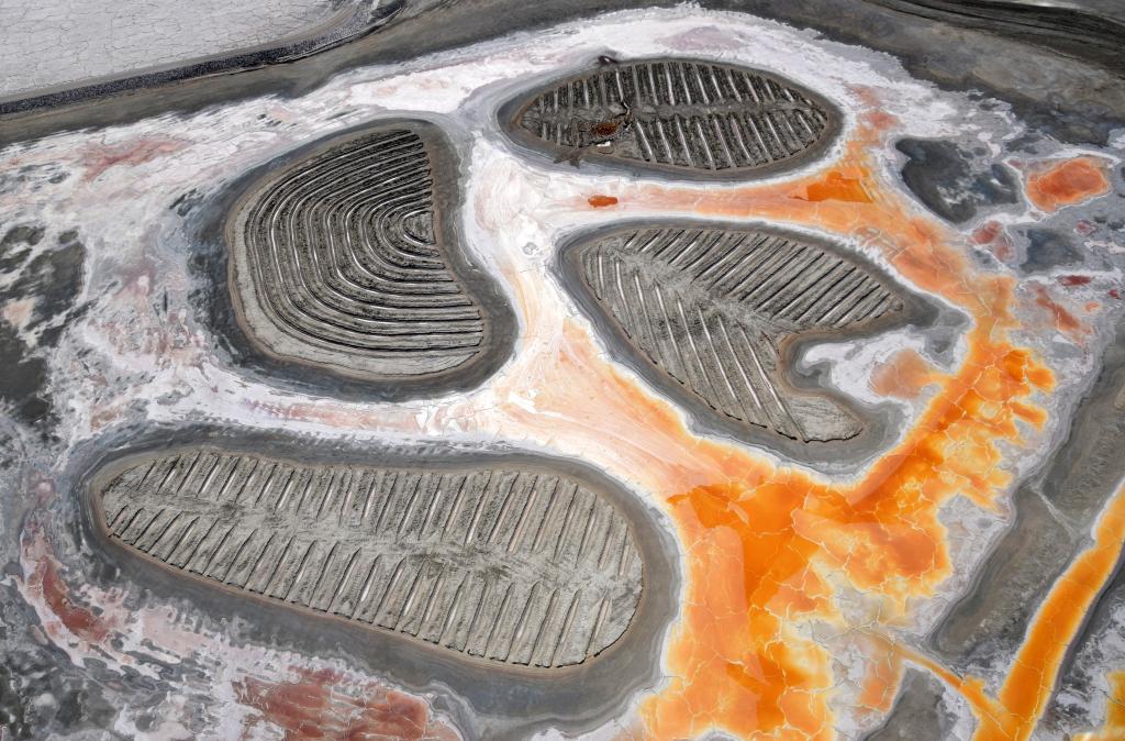
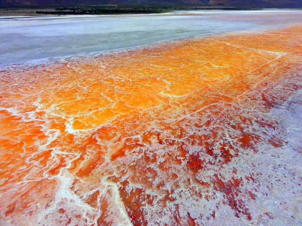
Owens Lake is primarily a salt lake with a large brine pool at its center. Brine with shallow flood backup is utilized in shallow flood dust control areas where salinity levels are high enough to create a salt crust that effectively curbs dust emissions. In these areas, 72 -75% of the surface must be covered with salt crust and/or saturated surfaces. Similar to the shallow flooding method, the saturated surfaces eliminate any sand or dust sources while capturing salt particles. The wind-resistant evaporite crust that forms as the standing brine evaporates seals the surface and reduces dust emissions. In some cases, saline shallow flood areas that are unable to meet the brine crust compliance criteria continue to be operated as shallow flood areas. If crust within a brine area breaks down, it is flooded to meet shallow flood wetness criteria, hence the term “back-up.” The stunning reds that paint these brine areas and the brine pool are attributed to salt-loving halobacteria.
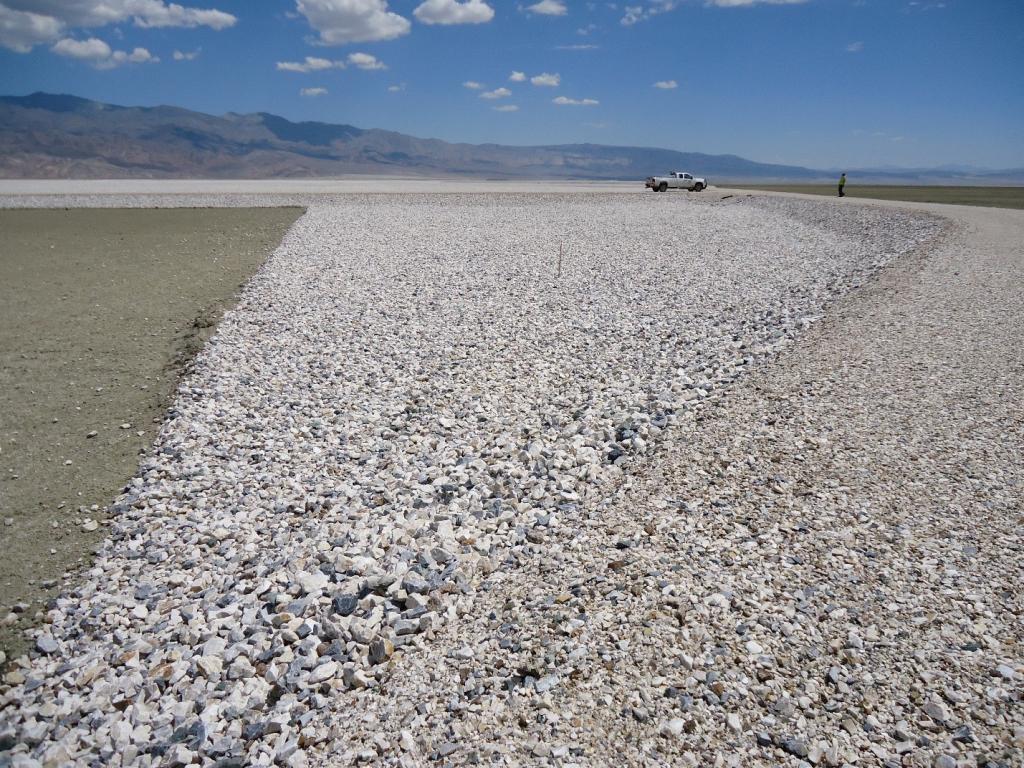
Gravel
Gravel cover is a zero-water-use BACM that involves distributing a layer of gravel on an emissive lakebed to protect it from the wind. Gravel protects the bare ground beneath it against wind erosion by substantially reducing salt and crust formation. Some areas are covered by 4 inches of gravel, while others are covered by 2 inches, underlain with a permanent permeable geotextile fabric to prevent the gravel from settling into the lakebed. The geotextile fabric is a 2.3-mm thick artificial fabric that is permeable to allow for drainage and is resistant to the acids and alkali elements of the soils. To protect the gravel-covered area from flooding, channels and drains are incorporated into the land surrounding the control area.
Tillage with Shallow Flooding Back Up
Tillage is a widely used method for wind erosion control in agricultural and arid regions around the world. It works by roughening the soil surface, reducing wind speed at the surface through the creation of turbulent eddies, which improves resistance to wind erosion. The roughened surface also creates traps to catch windblown soil particles. Installed tillage consists of rows and furrows in roughly east to west directions to create maximum surface roughness against high winds predominantly from the north and south. Where existing infrastructure has allowed, tillage has been installed in a serpentine pattern to provide additional protection from all wind directions. If the regulatory erosion threshold or any of the tillage performance requirements are no longer met, maintenance is performed to restore roughness, or shallow flooding is implemented as a backup control method.
Managed Vegetation
Managed Vegetation on the Owens Lake playa is an effective means of preventing and reducing dust emissions as it decreases both sand motion and soil erosion through the dissipation of wind energy. The above ground vegetation acts as a windbreak reducing wind velocity at the playa surface and consequentially reducing sand motion that leads to dust emissions. Vegetation cover assessments are performed each year using high-resolution photography and satellite imagery that ensure distribution requirements and minimum average coverage of 37% are met across all Managed Vegetation dust control areas. In addition, annual Plant health assessments are conducted to help guide routine maintenance activities throughout the year that include, but not limited to, strategic irrigation scheduling, bi-annual fertigation, as-needed reseeding, and drainage related improvements.
Water Management
Dust control infrastructure in the Owens Valley is expansive: the program covers approximately 48.6 square miles of lakebed and requires approximately 60,000 acre-feet of water annually. To put those numbers into perspective, 48.6 square miles is roughly the same size as the city of San Francisco and 60,000 acre-feet is enough to supply water to 240,000 single family households for an entire year. Eastern Sierra runoff delivered via the Los Angeles Aqueduct is the lowest cost water source available to LADWP rate payers. Therefore, every drop of water spread at Owens Lake is water that must be replaced by higher priced imported regional and State supplies. As regional and state water supplies continue to be stressed by climate change and drought conditions, it is imperative that Owens Lake dust mitigation balance water conservation while managing environmental resources such as wildlife habitat and cultural sites.
Click here for FY 23/24 imported water rates.
Owens Lake Scientific Advisory Panel
Established within the 2014 stipulated judgment, the Owens Lake Scientific Advisory Panel, under the National Academy of Sciences, was put in place to foster collaboration and communication between LADWP and GBUAPCD. The OLSAP reviews existing scientific literature and data and provides advisory recommendations and conclusions. The OLSAP’s initial task was included in the 2014 stipulated judgment, it includes analysis of the effectiveness existing dust controls, and other waterless, and water efficient methods for use at Owens Lake. The results of the initial study Effectiveness and Impacts of Dust Control Measures for Owens Lake were published in 2020.
In 2024, GBUAPCD issued a second task the OLSAP for analysis of off lake sources and possible dust controls.
Click here to learn more.